Sharp Island | 3 km | Moderate

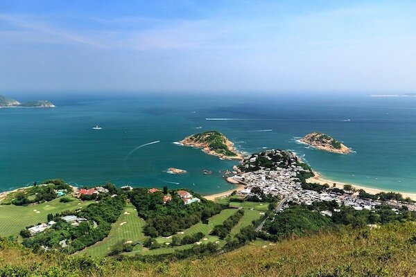
Located in the Hong Kong UNESCO Global Geopark, this tiny elongated island is home to geological spectacles created 140 million years ago. It is perfect for visitors to enjoy natural wonders, a fairly short hike and a dip in the sea in one go.

Sharp Island encapsulates Hong Kong's great outdoors at its best with lush greenery, clear waters, beautiful beaches and sweeping views. Photo credit: infinitenation.wordpress.com

Sharp Island encapsulates Hong Kong's great outdoors at its best with lush greenery, clear waters, beautiful beaches and sweeping views. Photo credit: infinitenation.wordpress.com

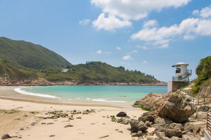
Starting point — Hap Mun Bay Beach

Hong-Kong-Tour_Guides-Hap-Mun-Bay.jpg

Start your day with a short bouncy kaito ride from the Sai Kung Public Pier. Hap Mun Bay, also known as Half Moon Bay, is a picturesque crescent-shaped beach tucked away at the southern tip of Sharp Island with emerald waters. In fact, it consistently tops the water quality ratings among Hong Kong’s beaches. A snack bar, barbecue and picnic sites, showers and lockers are available. Photo credit: unseenhongkong.com

Hak Shan Teng

Hong-Kong-Activities-Hak-Shan-Teng.jpg

The hiking route to Kiu Tau starts from the rear of the picnic site. It takes you to the top of the hill — Hak Shan Teng — for a breath-taking panorama of the coastline and the tombolo of Sharp Island. The trees, climbers and thickets along the way are so thick at some spots that it’s like walking through a green tunnel, where you will be greeted by a wide variety of fluttering butterflies. Photo credit: follo3me.com

Kiu Tsui Beach

Hong-Kong-Tour-Kiu-Tsui-Beach.jpg

After hiking for just an hour, Kiu Tsui Beach comes into sight. Partly bouldery and partly sandy, it’s a great spot for scuba-diving, kayaking, swimming and sunbathing. Photo credit: trover.com

Tombolo

Hong-Kong-Tour-Guides-Tombolo.jpg

If you happen to catch the low tide, witness the emerging promenade that connects the nearby Kiu Tau islet. Stroll along the natural sand levee for a closer look at this interesting coastal landform. Photo credit: unseenhongkong.com
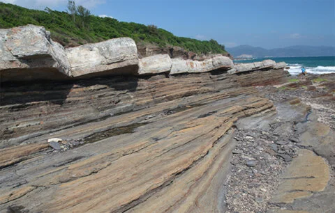

‘Pineapple buns’

Hong-Kong-Walking-Tours-Pineapple-Bun.jpg

Dozens of giant boulders are scattered on the tombolo beaches, looking bizarrely like the local snack ‘pineapple bun’. The quartz monzonite has been weathered and eroded to various degrees to yield irregular cracks. Other typical volcanic rocks found on Sharp Island include volcanic breccia and rhyolite, the former containing angular pyroclasts while the latter’s surface is adorned with lava flow bandings. Photo credit: travelwithkidz.com.au

Photo Tips from Kelvin Yuen

The tombolo is characterised by the many pineapple bun-shaped stones here. See the stone path connecting the Kiu Tau islet appear during low tide. Photo credit: discoverhongkong.com by Kelvin Yuen

Use an ultra-wide-angle lens (e.g. 16 mm) to capture the unique stones in the foreground and highlight the stone path.

*Winner of the National Geographic International Photo Contest 2015, Youth Division
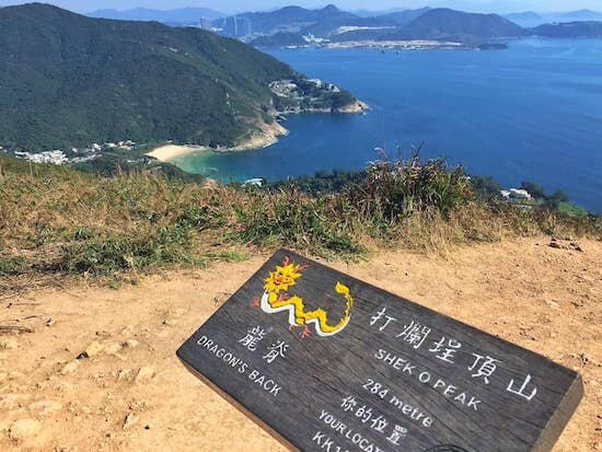
Kiu Tau

Hong-Kong-Local-Tours-Kiu-Tau.jpg

Cross the tombolo and follow the trail up Kiu Tau. From the hilltop lookout, you can get a good look at Hap Mun Bay, Port Shelter and Clear Water Bay. Descend to the rocky shore to observe coastal wildlife. At the end of the trail, you will see a beacon guiding ships in Inner Port Shelter. Photo credit: zh.wikipedia.org


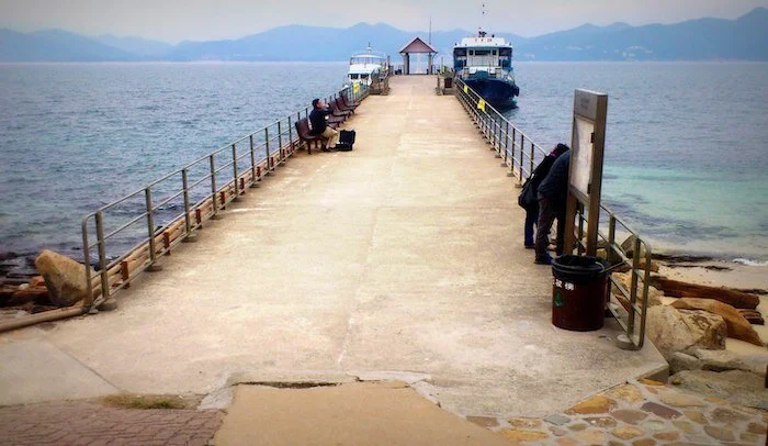
Endpoint — Sharp Island Pier

Hong-Kong-Day-Trips-Sharp-Island-Pier.jpeg

Return to the main island via the tombolo and walk towards the direction of Kiu Tsui Beach. The pier is an elevated platform where you can enjoy one last glimpse of the beautiful scenery before hopping onto the kaito. Photo credit: wanderingsnow.com

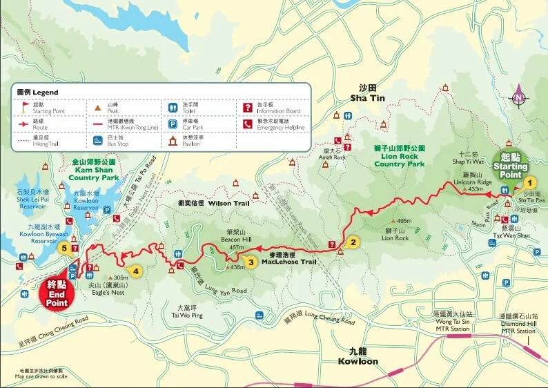
Click here for a better resolution of Sharp Island Trail map.

Info:
Area:
Sai Kung District
Starting point: Hap Mun Bay Beach
Endpoint:
Sharp Island Pier
Average hiking time: About 2 hours
Distance: Approximately 3 km
Replenishing stations: Sai Kung town centre has lots of options for stocking up.
Difficulty: Moderate - Short walk; but mind rugged relief at the tombolo and few stops for replenishment

How to get there:

  • To the starting point:

    • From MTR Diamond Hill Exit C2, take bus 92 to Sai Kung Town, then board a kaito at Sai Kung Public Pier to Hap Mun Bay.

    • Alternatively, from Sha Tin New Town Plaza Bus Terminus take bus number 299X to Sai Kung Town, then board a kaito at Sai Kung Public Pier.

    • The kaito ride takes around 15 minutes. An adult one-way ticket costs around $20-40. Costs vary between weekends and weekdays, and between peak season (summer) and low season.

    From the end point:

    • Board a kaito at Sharp Island Public Pier to return to Sai Kung Public Pier.

    • From Sai Kung Town, public transport is available to other destinations.

    • Sai Kung Ferry Traders Association (enquiry):
      +852 9080 5794 / +852 9082 2057


With thanks to the Hong Kong Tourism Board and discoverhongkong.com for the content.

Shing Mun Country Park | 9.7 km | Easy

Located in the southwestern New Territories, Shing Mun Country Park offers ample opportunities to explore nature. Hiking around nearby Tai Mo Shan, visitors can see tall paperbark trees lining the paths and, occasionally, come across groups of wild monkeys. An overwintering site for migrating brush-footed butterflies, the park is also perfect for butterfly watching, particularly in autumn.

Designated in 1977, Shing Mun Country Park was one of the first country parks in the territory. Photo credit: meocre.smugmug.com

Designated in 1977, Shing Mun Country Park was one of the first country parks in the territory. Photo credit: meocre.smugmug.com

Butterfly Paradise

Hong-Kong-Tour-Shing-Mun-Country-Park-butterfly.jpg

Migrating brush-footed butterflies winter in Shing Mun Country Park’s Butterfly Paradise. Commonly witnessed in the park are blue-spotted crows, glassy tigers and common tigers from the same butterfly family. Their beautiful but forbidding patterns are natural protection against predators. Photo credit: greenpower.org.hk

Pineapple Dam Nature Trail

Hong-Kong-Tour-Agency-Pineapple-Dam-Trail.jpg

Now a part of Shing Mun Reservoir, this dam used to be home to pineapple groves planted by Hakka villagers. Walking along the Nature Trail, visitors can enjoy picturesque views of Pineapple Dam and its 9 km-long catchwaters, as well as catch sight of wild monkeys. Photo credit: gethigh-hk.com

Paperbark Forest

Hong-Kong-Tour-Paperbark-Forest.jpg

The region around the reservoir is also a designated tree-planting site. The Paperbark Forest is a favourite with visiting photographers. Among the most picturesque scenery of the area are sky-high treetops, reflections of the forest on the glassy surface of the reservoir, and rows of paperbark trees submerged in the water. Photo credit: trover.com

Main Dam

Hong-Kong-Tour-Agency-Shing-Mun-Main-Dam.jpg

The construction of Shing Mun Reservoir was commissioned in 1923 and the dam took 14 years to complete. At 84 metres in height, its Main Dam is an impressive sight; of particular note is the dam’s distinctive bellmouth overflow device. The connected Lower Shing Mun Reservoir downstream catches overflowing water from the Main Dam. Photo credit: lcsd.gov.hk

Trip ideas:

  • Sunny afternoons are ideal for butterfly watching, from March to October.

  • The visitor centre provides a detailed introduction to the native monkeys. You can also learn more about the nearby military ruins and the abandoned mine with its tools and equipment. Open 9:30 a.m. to 4:30 p.m. on Saturdays, Sundays, and public holidays (except the first two days of Chinese New Year)

  • Don’t capture the butterflies.

  • Don’t tease or feed the monkeys. Keep your distance.

Click here for a better resolution of Shing Mun Country Park Trail map.

Info:
Area:
Tsuen Wan District
Starting point and Endpoint: Shing Mun Reservoir (Pineapple Dam) minibus terminus
Average hiking time: About 3 hours
Distance: About 9.7 km
Replenishing stations: There are no eateries or kiosks in the park.
Difficulty: Easy - Level paths throughout the area; suitable for all.


How to get there:

  • To the starting point:
    From MTR Tsuen Wan Station, Exit B1, take green minibus 82 on Shiu Wo Street for Shing Mun Reservoir.

    From the endpoint:
    From Shing Mun Reservoir (Pineapple Dam) minibus terminus, take green minibus 82 back to Shui Wo Street.


With thanks to the Hong Kong Tourism Board and discoverhongkong.com for the content.

Tung Ping Chau | 5 km | Fairly Easy

The easternmost island of Hong Kong is formed entirely of sedimentary rocks with a variety of marine abrasion landforms along its coast. The shores of this level island are decorated with colourful laminations of top rock shale and many other natural wonders.

Included in the Hong Kong UNESCO Global Geopark, Tung Ping Chau is an esteemed museum of geomorphology. Follow the simple trail around the island for a tour of its most popular attractions.

Tung Ping Chau is the farthest and wildest of Hong Kong outlying islands, being just 2 km off the mainland Chinese coast and Mirs Bay. Photo credit: commons.wikimedia.org

Tung Ping Chau is the farthest and wildest of Hong Kong outlying islands, being just 2 km off the mainland Chinese coast and Mirs Bay. Photo credit: commons.wikimedia.org

Starting Point — Tung Ping Chau Public Pier

Hong-Kong-City-Tour-Tung-Ping-Chau-pier.jpg

After a 1.5-hour ferry ride along Tolo Channel, you’ll arrive at the island. At the end of the pier you’ll find a sizeable public washroom, with the only flush toilets on the island. If you take a look around the pier, you’ll see corals and fish among the rocks under the limpid water of A Ma Wan.

Note: Mobile network coverage on the island is weak, and your phone may be connected to Mainland China networks instead. Switch off mobile data during the ferry ride to avoid unexpected roaming costs. Photo credit: wanderinghk.wordpress.com

A Ma Wan

Hong-Kong-Local-Tours-A-Ma-Wan.jpg

Walk left along the beach of A Ma Wan. As you enjoy the sea breeze and the sound of waves lapping the shore, keep an eye out for the amazing rock features here: wave-carved shale, iron-rich rocks weathered to resemble chequer boards, and stromatolitic structures made of fossils of cyanobacteria, just to name a few. Photo credit: discoverhongkong.com

Kang Lau Shek & rock pools

Hong-Kong-Day-Trips-Kang-Lau-Shek-rock-pools.jpg

At the easternmost tip of Tung Ping Chau, a pair of two-storey-high sea stacks majestically stand on a wave-cut platform, like the island’s watchtowers. During low tide, the platform becomes an intertidal paradise for small fishes, urchins and various shellfishes. Photo credit: walkonhill.com

Lung Lok Shui

Hong-Kong-Day-Tours-Lung-Lok-Shui.jpg

Return to the trail and walk for 30 minutes until you see a 100-metre-long band of rocks stretching off the coast from the hillside. With its triangular edges, it looks as though a dragon is making its way down into the ocean. This unique landform is carved from differential wave erosion of two rock layers. Photo credit: geopark.gov.hk


Cham Keng Chau

Hong-Kong-Tours-Cham-Keng-Chau.jpg

Continue on the trail in the woods until the view broadens. Descend the slope carefully, and you will be greeted by the boundless ocean and distinctively stratified shale bed, with Cham Keng Chau on your right. The spur, originally attached to the island, broke off from continuous erosion, and a natural corridor took shape. Walk along the passage between the sharp cliffs and enjoy the refreshing cool breeze. Photo credit: laughtraveleat.com

Ending Point — Tai Tong Village

Tours-in-Hong-Kong-Tai-Tong-village.jpg

Most of the villagers on Tung Ping Chau have moved out, but some of them return to the island during weekends and public holidays to run stalls for day-trippers. On your way back to the pier, you can stop by and see if any are open for a hot meal, fresh seafood dishes, snacks or cool drinks. Photo credit: en.wikipedia.org

Click here for a better resolution of Tung Ping Chau Trail map.

Info:
Area:
Tai Po District
Starting point and Endpoint: Tung Ping Chau Public Pier
Average hiking time: About 3 hours
Distance: Approximately 5 km
Replenishing stations: There is nowhere to buy food or drinks along most parts of the route, so stock up before setting out. Meals are available on weekends and public holidays at Tai Tong Village near the pier.
Difficulty: Fairly Easy - Relatively flat terrain with occasional wet and rough rock surfaces


How to get there:

  • To the starting point:
    From MTR University Station Exit B, take a taxi to Ma Liu Shui Ferry Pier and board a ferry. The journey takes around 1.5 hours. This ferry service operates only on Saturdays, Sundays and public holidays.

    From the endpoint:
    Board a ferry at Tung Ping Chau Public Pier. There is only one ferry back to Ma Liu Shui each day, so don’t miss it. This ferry service operates only on Saturdays, Sundays and public holidays.

    For the ferry service schedule, please refer to the Transport Department website.


With thanks to the Hong Kong Tourism Board and discoverhongkong.com for the content.

Sha Tin Pass Road to Kowloon Reservoir (Lion Rock) | 8 km | Difficult

Perched on the northern vista of Victoria Harbour, this trail runs high above the skyline of the Kowloon Peninsula with sweeping views of the most densely populated areas of Hong Kong. Walking along Lion Rock, Beacon Hill and Eagle’s Nest, glance north for views of the New Territories and south for a panorama of Kowloon. On a clear day, the view stretches to Victoria Harbour and the iconic skyline of Hong Kong Island, making it feel like the whole of Hong Kong is under your feet!

Lion Rock is located between Kowloon Tong of Kowloon and Tai Wai of the New Territories. Photo credit: thestandard.com.hk

Lion Rock is located between Kowloon Tong of Kowloon and Tai Wai of the New Territories. Photo credit: thestandard.com.hk

Did you know?

Lion Rock (495 m) is one of the most recognisable natural landmarks in Hong Kong and has become a symbol of the hardworking spirit of Hongkongers. The rock overlooks the major residential areas of the city and has stood as a witness to Hong Kong’s remarkable transformation from a rustic outpost of China to a dynamic world city. Beneath Lion Rock has been the name of a song and a TV series about the lives of ordinary Hong Kong people.

Starting Point — Sha Tin Pass Road

Hong-Kong-Day-Tours-Sha-Tin-Pass.jpg

From Wong Tai Sin or Diamond Hill MTR Station, take a taxi to Sha Tin Pass Road and stop at the Lion Pavilion (starting point of MacLehose Trail Section 5).

Before the era of motorised transportation and highways, Sha Tin Pass on the east of Lion Rock was an important route for villagers to commute between Sha Tin in the New Territories and Tsz Wan Shan in Kowloon. It is now called the Sha Tin Ancient Trail and attracts a lot of hikers and morning walkers. Photo credit: en.wikipedia.org

Reunification Pavilion

Tours-in-Hong-Kong-Reunification-Pavilion.jpg

This rain shelter on the Lion Rock was renamed as such in 1997 to commemorate the handover of Hong Kong to China. Stop for an open view of east Kowloon, the Kai Tak Cruise Terminal (formerly the runway of the Kai Tak Airport) and farther to Victoria Harbour and Hong Kong Island East. Photo credit: weshare.hk

Tze Kong Bridge

Hong-Kong-Tour-Guides-Beacon-Hill.jpg

At 458 m, this hill was an ancient military beacon. When the Kowloon–Canton Railway began  operation in 1910, the Beacon Hill Tunnel was the first to break through the natural barrier of mountain ridges separating Kowloon and the New Territories. Beacon Hill’s foothill on the Kowloon side is now a luxury residential area. The Beacon Hill Compass commands a view of the whole Kowloon Peninsula. Photo credit: droneandslr.com

Eagle’s Nest

Hong-Kong-Activities-Eagles-Nest.jpg

The hilltop of Eagle’s Nest (305 m) is inhabited by a number of black kites. The Eagle's Nest Nature Trail and MacLehose Trail Section 5 pass through here. Along here, you can enjoy views of West Kowloon. Photo credit: en.tripadvisor.com.hk


End Point — Kowloon Reservoir (Tai Po Road)

Hong-Kong-Tour-Kowloon-Reservoir.jpg

Completed in 1906, Hong Kong’s fourth reservoir now has five heritage-listed structures nearby, including the distinct arch dam. Photo credit: en.wikipedia.org

Click here for a better resolution of the Lion Rock Trail map.

Info:
Area:
Wong Tai Sin and Sha Tin districts
Starting point: Sha Tin Pass Road
Endpoint: Kowloon Reservoir (Tai Po Road)
Average hiking time: About 5 hours
Distance: Approximately 8 km
Replenishing stations: There is an eatery at the starting point at Sha Tin Pass Road where drinks and simple cooked food are available.
Difficulty: Difficult


How to get there:

  • From MTR Wong Tai Sin or Diamond Hill Station, take a taxi to Sha Tin Pass Road and stop at the Lion Pavilion (starting point of MacLehose Trail Section 5).


With thanks to the Hong Kong Tourism Board and discoverhongkong.com for the content.

The Corona Diaries - Sinclair | Hong Kong Tour Guide

Sinclair has been a tour guide for over 20 years but is one of the newest members of our team here at Hello! Hong Kong Tours. A multi-linguist, he speaks English, Mandarin, Cantonese and French! Sinclair has a fascinating background; born in Cambodia, he spent his childhood here in Hong Kong and then went to University in Canada where he graduated studied in Pure and Applied Science. One of 23 siblings his family is spread out all over the world, just like the Corona Virus!

Full of wanderlust like all of us, Sinclair has visited many countries and yet still finds Hong Kong, his hometown, as one of the best cities in the world! His genuine passion resonates with all of his guests on his tours and he will definitely make you fall in love with Hong Kong.

Now, that every country has travel restrictions including Hong Kong, how does he spend his free time? Let’s check out Sinclair’s Corona Diary below!

Hello! Hong Kong tour guide Sinclair all smile enjoying the beautiful day at the sea!

Hello! Hong Kong tour guide Sinclair all smile enjoying the beautiful day at the sea!

On a normal day, you are usually out on the streets showing our guests the beauty of Hong Kong. Given the travel restrictions imposed by several countries. How are you spending your time now? What keeps you busy?

For the last few months, I mostly stay home watching TV, doing some household chores, and had some improvements in my cooking. On a sunny warm day, I prefer outdoor activities, such as jogging and hiking.

We know that you also suffer from wanderlust. When this Pandemic is finally over, and you can go anywhere overseas where will your wanderlust take you and why?

If the Pandemic is finally over, I would like to visit Thailand again. I like their culture, food and especially their smiling and enthusiastic hospitality.

After the world comes out of this dark time and everyone can travel to Hong Kong again what is the thing or place you are most excited about showing our guests and why?

If the whole world goes back to normal, and if overseas visitors return to visit Hong Kong, the first place I would like to show them is The Peak where you can see the beautiful, well developed, nice and clean city. I will also bring them to try the traditional food tasting as it brings people happiness as always.

What is the one thing that you this very unfortunate event taught you and why?

From this epidemic, it taught me that we should stand up and face all difficulties. In time, we will all heal. We should not forget and always remember that there is sunshine in every rain.

#thetravellingnomads #intravelist #backpackersintheworld #travel #beautifulseason #tripscout #digitalnomad #sustainabletravel #photographeveryday #amazing #photographyislife #keepexploring #livetoexplore #wandering #travelanddestinations #seetheworld #tlpick #travellingthroughtheworld #postcardsplace #missyoutoo #wewillriseagain #wewillgetthroughthis

Hong Kong Tour | Helicopter Tour

COVID-19 gave a full blow not only to Hong Kong but to the world. To prevent the further spread of the virus, the Hong Kong government has imposed social distancing measures in the city. No social gathering of more than 3 is allowed, theme parks and bars are closed. Thanks to the cooperation of the Hong Kong people that it has been weeks that there are no reported positive cases in the city!

Positive news that the government is beginning to relaxed the social distancing measure in the city. If you are still having thoughts of walking around the city but still want to explore Hong Kong, we can make sightseeing in the sky!

You can now start booking Hello! Hong Kong Tour Helicopter private Charter available only on certain dedicated days, namely Fri, Sat, Sun, Mon (long weekends).

Hong Kong is one of the most visually breathtaking cities on the planet. what perfect way to truly see Hong Kong and its contrasting landscapes is by air!

#thetravellingnomads #intravelist #backpackersintheworld #travel #beautifulseason #tripscout #digitalnomad #sustainabletravel #photographeveryday #amazing #photographyislife #keepexploring #livetoexplore #wandering #travelanddestinations #seetheworld #tlpick #travellingthroughtheworld #postcardsplace #MissYouToo #Missyouhk #missyouhongkong

Wilson Trail (Wong Nai Chung Reservoir to Stanley Gap Road) | 4.8 km | Very Difficult

The short yet challenging Section 1 of the Wilson Trail offers rewarding encounters with nature with its abundance of beautiful flowering shrubs. Once you’ve conquered Violet Hill and the Twins, the view on the ridgeline opens out to Stanley Village, D’Aguilar Peninsula, and the ocean beyond.

Wilson Trails at 70 kilometre long, has 10 sections which links the eight country parks from south to north of Hong Kong. Photo credit: timeout.com

Wilson Trails at 70 kilometre long, has 10 sections which links the eight country parks from south to north of Hong Kong. Photo credit: timeout.com

Wong Nai Chung Reservoir

Hong-Kong-Tour-Guides-Wong-Nai-Chung-Reservoir.jpg

Check out the Wong Nai Chung Reservoir Park before hiking uphill. Completed in 1889, some of the reservoir’s original components, including the weir, the dam, and the valve house, have been preserved, and are classified as Grade III historic buildings. Photo credit: fso-createhk.gov.hk

Violet Hill

Hong-Kong-Tour-Violet-Hill.jpg

After the park, return to Tai Tam Reservoir Road, then turn right to enter the Wilson Trail. On the trail, you will first tackle the relatively gentle Violet Hill, followed by the steeper ascent and descent of the Twins. From late January through early February, Violet Hill is covered in flowers. With their bell-shaped, violet-coloured blooms, the wild enkianthus shrubs will definitely grab your attention. Photo credit: urban-outdoors.com

Tze Kong Bridge

Hong-Kong-Tour-Agency-Tze-Kong-Bridge.jpg

As you descend from Violet Hill, you can see Repulse Bay Beach. Upon crossing Tze Kong Bridge, follow the sign that directs you to Stanley Gap Road until you see a flight of 1,200 steps leading up to the Twins. Particularly from November through January, you’ll find the trail lined with abundant Polyspora axillaris flowers. They’re also known as the “fried-egg plants” because of the flower’s yellow and white colouration. Photo credit: photoblog.com

The Twins

Hong-Kong-Walking-Tours-The-Twins.jpg

The wide-open view of Stanley on top of the Twins is a blissful finale to the hike. As you make your descent on Stanley Gap Road, spot the beautiful St. Stephen’s Beach, Stanley Peninsula, Stanley Main Beach, Murray House, and many more iconic attractions as you descend to Stanley Gap Road. Photo credit: pinterest.com

  • Trip ideas: Don’t pick the wild plants.

Click here for a better resolution of the Wilson Trail map.

Info:
Area:
Southern District
Starting point: Wong Nai Chung Reservoir
Endpoint: Stanley Gap Road
Average hiking time: 3 hours
Distance: About 4.8 km
Replenishing stations: No refueling stops along the hike. It’s essential to stock up on water and supplies beforehand.
Difficulty: Very Difficult - It’s a physically demanding hike with very little to no shade. A steep climb and descent near the Twins are to be expected.


How to get there:

  • From MTR Causeway Bay Station Exit D, take green minibus 5 at the crossroad of Jaffe Road and Cannon Street to Wong Nai Chung Reservoir. You can also take bus 76 on Pennington Street.

  • From MTR Hong Kong Station Exit D, take bus 6 at the Exchange Square Bus Terminus.

  • At the Wong Nai Chung Reservoir Park bus stop, you will see a petrol station. From there, cross the road and head up Tai Tam Reservoir Road to walk for about 10 minutes to Hong Kong Parkview. Wong Nai Chung Reservoir will be on your right.

    From the endpoint:

  • There are several bus routes you can take. Go to the other side of Stanley Gap Road, and take bus 6, 6A, or 260 to Wan Chai, Admiralty, or Central, or bus 73 to Aberdeen.

  • If you stay on the same side of the road, you can take bus 6, 6A, 73, or 260 to Stanley. You may catch a taxi ride back to Central from Stanley Gap Road.


With thanks to the Hong Kong Tourism Board and discoverhongkong.com for the content.

Tai Tam Country Park to Quarry Bay | 8km | Moderate

Built between 1883 and 1917, the Tai Tam Reservoirs were vital to the city’s urban development. Steady freshwater supply enabled industrial development to flourish. The area was so strategic that it became a battleground during World War II. Today, you can still find remnants of the war, such as pillboxes, bunkers and wartime communal stoves hiding in tranquil woodland.

The adjacent Tai Tam Country Park (Quarry Bay Extension) is a smaller sanctuary designated in 1979. Photo credit: industrialhistoryhk.org

The adjacent Tai Tam Country Park (Quarry Bay Extension) is a smaller sanctuary designated in 1979. Photo credit: industrialhistoryhk.org

Starting Point — Wong Nai Chung Reservoir

Hong-Kong-Day-Tours-Wong Nai Chung Reservoir.jpg

Literally ‘yellowish muddy creek’, Wong Nai Chung was dammed in 1899 to form Wong Nai Chung Reservoir. Have fun spotting kois, catfishes and tortoises. The nearby Wong Nai Chung Gap was a strategic defensive position during World War II. On 18 December 1941, Japanese troops began advancing up the hills from the north shore to capture the gap after some of the fiercest fighting of the invasion. Photo credit: thepoortraveler.net

Tai Tam Group of Reservoirs

Hong-Kong-Tours-Tai-Tam-Reservoir.jpg

Enjoy the shade as you pass by Hong Kong Parkview onto the paved path towards the reservoirs of Tai Tam. On any clear day, you’ll see perfect reflections of the hills and bridges on the glassy water surface.

To cater to the ever-increasing demand for water, towards the end of the 19th century, parts of the rugged valley of Tai Tam were dammed. The improved water supply made way for urbanisation to be extended from ‘Victoria City’ to the eastern side of Hong Kong Island. Photo credit: industrialhistoryhk.org

Quarry Gap

Hong-Kong-Tour-Quarry-Gap.jpg

Take a break at this crossroad of Mount Parker Road and the Hong Kong Trail. The Cantonese name of this hill pass, ‘Tai Fung Au’, means ‘windy gap’, and perfectly captures the breeziness of this hikers’ rest stop. Photo credit: topick.hket.com

Wartime Stoves

Hong-Kong-Tour-Agency-Wartime-Stoves.jpg

Follow the pleasantly shaded Mount Parker Road to the Hong Pak Country Trail, then turn onto the Quarry Bay Tree Walk. You will find dozens of field stoves, which were built as part of the city’s defence preparations during World War II. Photo credit: youtube.com

Woodside Biodiversity Education Centre

Hong-Kong-Tour-Woodside-Biodiversity-Education-Centre.jpg

From the end of the walk, continue on Mount Parker Road Green Trail for 15 minutes, until an exquisite red brick house comes into sight. Formerly the residence of Taikoo Sugar Refinery, which at one time was the world’s largest single unit refinery, this quaint mansion built in the 1920s was used briefly for refugees during World War II. Now, it showcases the biodiversity and conservation efforts in Hong Kong through interactive galleries.

End Point — Tong Chong Street

Hong-Kong-City-Tour-Tong-Chong-Street.jpg

As you finish the hike and head to MTR Quarry Bay Station, you’ll come across Tong Chong Street — literally ‘Sugar Refinery Street’ in Chinese. Glass-windowed skyscrapers have now replaced factory buildings, and cafés and pubs line both sides of the street instead of piles of sugar cane. Photo credit: zh.wikipedia.org

Click here for a better resolution of the Tai Tam Country Park to Quarry Bay map.

Info:
Area:
Southern and Eastern Districts
Starting point: Wong Nai Chung Reservoir
Endpoint: Tong Chong Street
Average hiking time: About 3 hours
Distance: Approximately 8 km
Replenishing stations: There is a supermarket at Hong Kong Parkview. Fuel up at cafés and restaurants on Tong Chong Street or King’s Road after the hike.
Difficulty: Moderate
Level and mostly shaded paths with some uphill sections

How to get there:

To the starting point:
From MTR Hong Kong Station Exit A, take bus 6 or 66 or from the Exchange Square bus terminus to Wong Nai Chung Gap Road.

From the endpoint:
Head to your next destination from MTR Quarry Bay Station.


With thanks to the Hong Kong Tourism Board and discoverhongkong.com for the content.

Peak Circle Walk | 3.5km | Easy

The top thing to do in Hong Kong is to take in the world-famous vista of Victoria Harbour from The Peak. Some of the best views are on the Peak Circle Walk, which winds around the highest point on Hong Kong Island.

Did you know?
There is more than one way to circle a peak. Do this walk in reverse, starting around 90 minutes before sunset, and you’ll be looking at Hong Kong Island’s scenic south side in the glow of afternoon light. You’ll be coming around to the north side, with views of the harbour, at just the right time, when twilight gives way to night and the city becomes a galaxy of shimmering lights.

The Peak Circle Walk loops around the highest point on Hong Kong Island, ensuring the best views from every angle. Photo credit: travelvui.com

The Peak Circle Walk loops around the highest point on Hong Kong Island, ensuring the best views from every angle. Photo credit: travelvui.com

Starting Point

Hello Hong Kong Hike Guide Peak

*Photos were taken before after the Peak Tram renovation.

Photo credit: Jamie of J3PrivateTours

From MTR Central Station, take the steps at Exit J2, or take Exit K which has escalators and leads directly into Statue Square. Walk to the lower Peak Tram terminus located on Garden Road for the scenic ride up to The Peak. Alternatively, you can take bus 15 from Exchange Square bus terminus, or minibus 1 from MTR Hong Kong Station public transport interchange. The Peak Circle Walk begins at Lugard Road near the Peak Tower.

Lugard Road

Hong-Kong-Tour-Lugard-Road-Lookout.jpg

Built in 1913–14, this road is named after Hong Kong’s 14th governor, Sir Fredrick Lugard. The sections that are narrow, cliff-side paths are called ‘plank roads’. After about 20 minutes, you’ll arrive at the Lugard Road lookout, which offers a spectacular panoramic view of Victoria Harbour. Photo credit: dailytravelpill.com

Harlech Road

Hong-Kong-Tour-Agency-Harlech-Road-Waterfall.jpg

Lugard Road runs into Harlech Road, which will slowly take you back to The Peak Tower and to the end of your lap around The Peak. It takes about 15 minutes to traverse the entire tree-shaded path, or a bit longer if you stop to appreciate the waterfall falling below Mount Austin Playground. Watch out for those joggers rushing past: Harlech Road is one of their favourites. Photo credit: hk-victoria-peak.com

End Point

Hong-Kong-City-Tour-The-Peak-Tower.jpg

The walk will take you back to its starting point near The Peak Tower. From here you can catch the Peak Tram, bus 15 or minibus 1 back down to Central. Photo credit: thepeak.com.hk

Lung Fu Shan Country Park

Hong-Kong-Local-Tours-Lung-Fu-Shan-Country-Park.jpg

Take it farther! If time and energy are on your side, you can turn this leisurely stroll into a substantial walk to Lung Fu Shan Country Park. For something more in between, you can head to Pinewood Battery by turning right onto Hatton Road at the intersection of Lugard and Harlech roads. From here, take a tour of the University of Hong Kong and return to Central on bus 13 from Kotewall Road. Photo credit: flickr.com


Click here for a better resolution of The Peak map.

Info:
Area:
The Peak, Hong Kong Island
Starting point: Lugard Road
Endpoint: Harlech Road
Average hiking time: About 1.5 hours
Distance: 3.5 km
Replenishing stations: There is no replenishing station along the route. So before starting out, fuel up at a restaurant or stock up at a store in The Peak Galleria or The Peak Tower.
Difficulty: Easy


With thanks to the Hong Kong Tourism Board and discoverhongkong.com for the content.

Dragon's Back | 8.5km | Moderate

The last leg of the Hong Kong Trail, this meandering path on the ridge of Dragon’s Back is widely hailed as one of Hong Kong’s best urban hikes. Besides its attractive name, Dragon’s Back has a sightseeing platform near the peak that provides truly spectacular views of southern Hong Kong Island and its shoreline. Right at the trail’s end is Big Wave Bay. Take a dip or surf the waves for a relaxing finale to this hike.

It is arguably the best hike on Hong Kong Island. Photo credit: traveller.com.au

It is arguably the best hike on Hong Kong Island. Photo credit: traveller.com.au

Shek O Peninsula Viewing Point

Hong-Kong-Day-Tours-Shek-O-Peninsula-Viewing-Point.jpg

From Shek O Road, you will first walk through a shaded path onto this section of the Hong Kong Trail. About a minute into your hike, the path will open up to the sky as you ascend. After 20 minutes or so, you’ll find yourself on the Shek O Peninsula Viewing Point overlooking Shek O Beach on the foot of the hill, and also the two isles off Shek O Peninsula. Photo credit: canon.com.hk

Shek O Peak

Tours-in-Hong-Kong-Dragons-Back-Shek-O-Peak.jpg

Although bare and exposed, the platform on the summit of Shek O Peak (284 m) is the perfect place to take in the panorama of the peninsula’s coastline. When you turn around to observe the winding trails, you’ll finally see how Dragon’s Back got its well-deserved name. Photo credit: themcnuggetsqueen.com

Dragon’s Back & Pottinger Gap

Hong-Kong-Walking-Tours-Dragons-Back-Pottinger Gap.jpg

Stay on the rolling ridge to trace the “dragon” while you climb uphill. Stop at the Dragon’s Back Viewing Point for a great view of the Tai Tam Bay west of Shek O Peninsula. On a clear day, even Lamma Island, to the southwest of Hong Kong Island, is visible from the deck. Once over the ridge, you'll arrive at Pottinger Gap. Here you get a view of Chai Wan’s urban high-rises against a forested landscape. Photo credit: walkonhill.com

Big Wave Bay

Tours-in-Hong-Kong-Big-Wave-Bay.jpg

After passing a pavilion, you’ll begin a sharp descent on an uneven stone and dirt path. This very last stage of the trail is mostly shaded and can be slippery at times. Once you’ve exited the trail and cleared the village houses, a beach popular with surfers lies waiting. Big Wave Bay will greet your arrival with shimmering white waves against the blue sky. Photo credit: thetraveler.net

Trip ideas: If you plan on watching the sunrise or sunset on Dragon’s Back, check the Hong Kong Observatory website for the exact times: www.hko.gov.hk


Click here for a better resolution of the Dragon's Back’s trail map.

Info:
Area:
Southern District
Starting point: Shek O Road near To Tei Wan Village
Endpoint: Big Wave Bay
Average hiking time: 4 hours
Distance: About 8.5 km
Refuel: There are no refueling stops along the trail.
Difficulty: Moderate
Most of the route is on dirt paths. The first half has very little shade, and there is also a steep 200-meter-long uphill stretch. The flight of descending stone steps in the last section is quite steep, too.


How to get there:

To the starting point:
From MTR Shau Kei Wan Station Exit A, walk to the Shau Kei Wan Bus Terminus. Take bus 9 or the red minibus with the sign “Shek O” to the To Tei Wan stop on Shek O Road.

From the endpoint:
Take the red minibus with the sign “Shau Kei Wan” or a taxi from Big Wave Bay back to Shau Kei Wan.


With thanks to the Hong Kong Tourism Board and discoverhongkong.com for the content.