
Sha Tin Pass Road to Kowloon Reservoir (Lion Rock) | 8 km | Difficult
Perched on the northern vista of Victoria Harbour, this trail runs high above the skyline of the Kowloon Peninsula with sweeping views of the most densely populated areas of Hong Kong. Walking along Lion Rock, Beacon Hill and Eagle’s Nest, glance north for views of the New Territories and south for a panorama of Kowloon. On a clear day, the view stretches to Victoria Harbour and the iconic skyline of Hong Kong Island, making it feel like the whole of Hong Kong is under your feet!

Lion Rock is located between Kowloon Tong of Kowloon and Tai Wai of the New Territories. Photo credit: thestandard.com.hk
Did you know?
Lion Rock (495 m) is one of the most recognisable natural landmarks in Hong Kong and has become a symbol of the hardworking spirit of Hongkongers. The rock overlooks the major residential areas of the city and has stood as a witness to Hong Kong’s remarkable transformation from a rustic outpost of China to a dynamic world city. Beneath Lion Rock has been the name of a song and a TV series about the lives of ordinary Hong Kong people.
Starting Point — Sha Tin Pass Road

From Wong Tai Sin or Diamond Hill MTR Station, take a taxi to Sha Tin Pass Road and stop at the Lion Pavilion (starting point of MacLehose Trail Section 5).
Before the era of motorised transportation and highways, Sha Tin Pass on the east of Lion Rock was an important route for villagers to commute between Sha Tin in the New Territories and Tsz Wan Shan in Kowloon. It is now called the Sha Tin Ancient Trail and attracts a lot of hikers and morning walkers. Photo credit: en.wikipedia.org
Reunification Pavilion

This rain shelter on the Lion Rock was renamed as such in 1997 to commemorate the handover of Hong Kong to China. Stop for an open view of east Kowloon, the Kai Tak Cruise Terminal (formerly the runway of the Kai Tak Airport) and farther to Victoria Harbour and Hong Kong Island East. Photo credit: weshare.hk
Tze Kong Bridge
At 458 m, this hill was an ancient military beacon. When the Kowloon–Canton Railway began operation in 1910, the Beacon Hill Tunnel was the first to break through the natural barrier of mountain ridges separating Kowloon and the New Territories. Beacon Hill’s foothill on the Kowloon side is now a luxury residential area. The Beacon Hill Compass commands a view of the whole Kowloon Peninsula. Photo credit: droneandslr.com
Eagle’s Nest

The hilltop of Eagle’s Nest (305 m) is inhabited by a number of black kites. The Eagle's Nest Nature Trail and MacLehose Trail Section 5 pass through here. Along here, you can enjoy views of West Kowloon. Photo credit: en.tripadvisor.com.hk
End Point — Kowloon Reservoir (Tai Po Road)
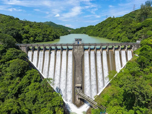
Completed in 1906, Hong Kong’s fourth reservoir now has five heritage-listed structures nearby, including the distinct arch dam. Photo credit: en.wikipedia.org
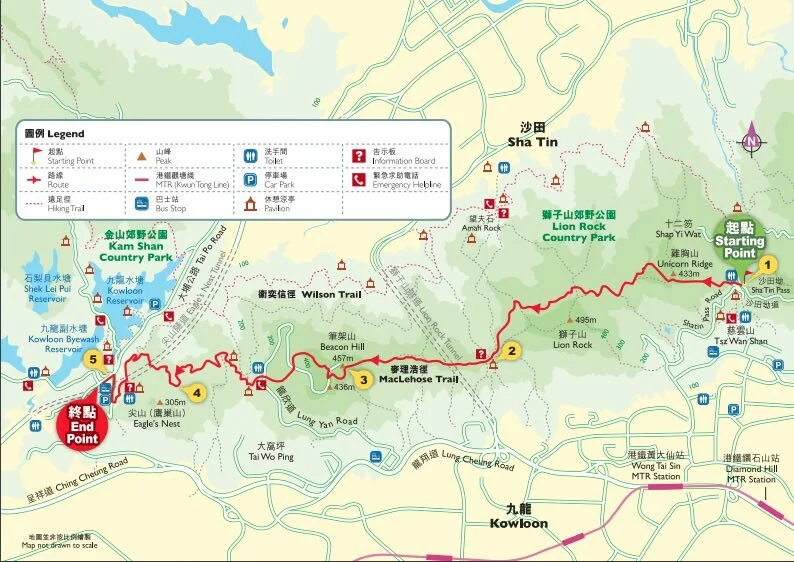
Click here for a better resolution of the Lion Rock Trail map.
Info:
Area: Wong Tai Sin and Sha Tin districts
Starting point: Sha Tin Pass Road
Endpoint: Kowloon Reservoir (Tai Po Road)
Average hiking time: About 5 hours
Distance: Approximately 8 km
Replenishing stations: There is an eatery at the starting point at Sha Tin Pass Road where drinks and simple cooked food are available.
Difficulty: Difficult
How to get there:
From MTR Wong Tai Sin or Diamond Hill Station, take a taxi to Sha Tin Pass Road and stop at the Lion Pavilion (starting point of MacLehose Trail Section 5).