
Tung Ping Chau | 5 km | Fairly Easy
The easternmost island of Hong Kong is formed entirely of sedimentary rocks with a variety of marine abrasion landforms along its coast. The shores of this level island are decorated with colourful laminations of top rock shale and many other natural wonders.
Included in the Hong Kong UNESCO Global Geopark, Tung Ping Chau is an esteemed museum of geomorphology. Follow the simple trail around the island for a tour of its most popular attractions.

Tung Ping Chau is the farthest and wildest of Hong Kong outlying islands, being just 2 km off the mainland Chinese coast and Mirs Bay. Photo credit: commons.wikimedia.org
Starting Point — Tung Ping Chau Public Pier
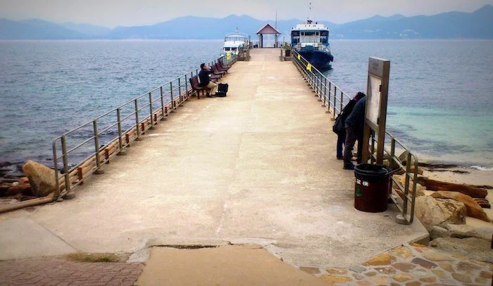
After a 1.5-hour ferry ride along Tolo Channel, you’ll arrive at the island. At the end of the pier you’ll find a sizeable public washroom, with the only flush toilets on the island. If you take a look around the pier, you’ll see corals and fish among the rocks under the limpid water of A Ma Wan.
Note: Mobile network coverage on the island is weak, and your phone may be connected to Mainland China networks instead. Switch off mobile data during the ferry ride to avoid unexpected roaming costs. Photo credit: wanderinghk.wordpress.com
A Ma Wan

Walk left along the beach of A Ma Wan. As you enjoy the sea breeze and the sound of waves lapping the shore, keep an eye out for the amazing rock features here: wave-carved shale, iron-rich rocks weathered to resemble chequer boards, and stromatolitic structures made of fossils of cyanobacteria, just to name a few. Photo credit: discoverhongkong.com
Kang Lau Shek & rock pools

At the easternmost tip of Tung Ping Chau, a pair of two-storey-high sea stacks majestically stand on a wave-cut platform, like the island’s watchtowers. During low tide, the platform becomes an intertidal paradise for small fishes, urchins and various shellfishes. Photo credit: walkonhill.com
Lung Lok Shui
Return to the trail and walk for 30 minutes until you see a 100-metre-long band of rocks stretching off the coast from the hillside. With its triangular edges, it looks as though a dragon is making its way down into the ocean. This unique landform is carved from differential wave erosion of two rock layers. Photo credit: geopark.gov.hk
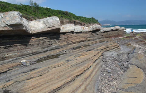
Cham Keng Chau

Continue on the trail in the woods until the view broadens. Descend the slope carefully, and you will be greeted by the boundless ocean and distinctively stratified shale bed, with Cham Keng Chau on your right. The spur, originally attached to the island, broke off from continuous erosion, and a natural corridor took shape. Walk along the passage between the sharp cliffs and enjoy the refreshing cool breeze. Photo credit: laughtraveleat.com
Ending Point — Tai Tong Village

Most of the villagers on Tung Ping Chau have moved out, but some of them return to the island during weekends and public holidays to run stalls for day-trippers. On your way back to the pier, you can stop by and see if any are open for a hot meal, fresh seafood dishes, snacks or cool drinks. Photo credit: en.wikipedia.org

Click here for a better resolution of Tung Ping Chau Trail map.
Info:
Area: Tai Po District
Starting point and Endpoint: Tung Ping Chau Public Pier
Average hiking time: About 3 hours
Distance: Approximately 5 km
Replenishing stations: There is nowhere to buy food or drinks along most parts of the route, so stock up before setting out. Meals are available on weekends and public holidays at Tai Tong Village near the pier.
Difficulty: Fairly Easy - Relatively flat terrain with occasional wet and rough rock surfaces
How to get there:
To the starting point:
From MTR University Station Exit B, take a taxi to Ma Liu Shui Ferry Pier and board a ferry. The journey takes around 1.5 hours. This ferry service operates only on Saturdays, Sundays and public holidays.
From the endpoint:
Board a ferry at Tung Ping Chau Public Pier. There is only one ferry back to Ma Liu Shui each day, so don’t miss it. This ferry service operates only on Saturdays, Sundays and public holidays.
For the ferry service schedule, please refer to the Transport Department website.