
Winding round the Sai Kung Peninsula, this hike covers Section 1 and part of Section 2 of the MacLehose Trail, providing one of the best ways to see the amazing hexagonal volcanic columns of High Island. The route also passes the High Island Reservoir and Long Ke Wan, which have been voted as two of Hong Kong’s best scenic sites.
Section 1 of the trail cuts through the lower half of the Sai Kung East Country Park, passing both the West Dam and East Dam of the High Island Reservoir. Most of the route consists of flat roads and concrete paths.

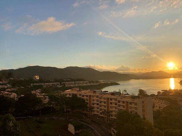
Sai Kung Peninsula is one of the last havens left in Hong Kong for hikers, swimmers and boaters, and most of it is one beautiful 7500-hectare country park. Photo credit: en.wikipedia.org
Starting point — Sai Kung Country Park Visitor Centre

From MTR Diamond Hill Station, Exit C2, take bus 92 to Sai Kung Peninsula. From Sai Kung town catch bus 94 towards Wong Shek pier and alight at Pak Tam Chung Station. On Sundays, it’s possible to take bus 96R from MTR Diamond Hill Station directly to Pak Tam Chung Station. From Pak Tam Chung Station, walk along Tai Mong Tsai Road for approximately five minutes until you reach the start of the trail. Photo credit: platform.hkdiscovery.com
High Island Reservoir West Dam

From the West Dam of High Island Reservoir, take in the panoramic view of the surrounding mountains and coast. Built between 1971 and 1979, the reservoir has a capacity of 280 million cubic metres, surpassing any other in the city. Since November 2009, it has been listed as part of the Hong Kong UNESCO Global Geopark, not least because of its sizeable series of acidic rhyolite volcanic columns that are rarely seen elsewhere in the world. Photo credit: attator.blogspot.com
East Dam

After hiking for just an hour, Kiu Tsui Beach comes into sight. Partly bouldery and partly sandy, it’s a great spot for scuba-diving, kayaking, swimming and sunbathing. Photo credit: trover.com
Tombolo

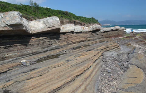
At the East Dam you’ll be able to see hexagonal rock columns resembling a ‘petrified waterfall’. These are hundreds of millions of years old and were formed by the cooling and contracting mixture of lava, rock debris and volcanic ash. Later, consistent violent crustal movements created the twists and folds that you can now see. Photo credit: blog.sina.com.cn
From the East Dam you will also have a good view of Po Pin Chau; an islet that looks like it was chopped off from the adjacent rock by a giant axe. It used to be part of High Island, but became dislocated by the chronic erosion of powerful waves. Those who paid attention in geography class will remember that this is called a sea stack.
The East Dam is a cofferdam of 7,000 dolosse protecting Sai Kung’s coast from the relentless forces of the ocean. Look out for the giant dolos on the trail commemorating the workers who died during the construction of High Island Reservoir.
Long Ke Wan

A splendid inner bay, Long Ke Wan has crystal-clear water and a blanket of white sands resting between hills and capes. Conic Island is the only land to be seen in what is an otherwise immense view of the open South China Sea. Photo credit: beach-weather.com
Endpoint — Sai Wan Pavilion

From Sai Wan Pavilion take minibus NR29 or a taxi back to Sai Kung Town. Photo credit: trailhiker.wordpress.com

Click here for a better resolution of Sai Kung Peninsula Trail map.
Info:
Area: Sai Kung, New Territories
Starting point: Pak Tam Chung
Endpoint: Chui Tung Au (Sai Wan Pavilion)
Average hiking time: Approximately 7 hours
Distance: Approximately 14 km
Replenishing stations: There is a refreshment kiosk near the Pak Tam Chung Parking Area.
Difficulty: Moderate
How to get there:
To the starting point:
From MTR Diamond Hill Station Exit C2, take bus 92 to Sai Kung Bus Terminus. Then at Sai Kung Town, take bus 94 for Wong Shek Pier and get off at Pak Tam Chung Station; or
take bus 96R for Wong Shek Pier (this route only operates on Sundays and public holidays) from MTR Diamond Hill Station Exit C2 and get off at Pak Tam Chung Station.
Alternatively, From Sha Tin New Town Plaza Bus Terminus, take bus 299X to Sai Kung Bus Terminus. Then at Sai Kung Town, take bus 94 for Wong Shek Pier and get off at Pak Tam Chung Station.After getting off the bus at Pak Tam Chung Station, you’ll find the Pak Tam Chung Barrier Gate. Walk along Tai Mong Tsai Road for five minutes to the starting point of the trail.
From the endpoint:
Take NR29 minibus or a taxi back to Sai Kung Town.