
Lantau Island - Tung Chung to Tai O | 14.5 km | Difficult
On Lantau Island, the Tung O Ancient Trail was once an important passage for villagers to commute between Tung Chung and Tai O. The coastal trail offers manifold photography opportunities, from the futuristic mega infrastructures of Hong Kong International Airport and the Hong Kong-Zhuhai-Macao Bridge (under construction) to an ancient fort, temples and a centuries-old fishing village set against mangroves and green hills.

The trail offers a beautiful path along the coastal line overlooking Hong Kong-Zhuhai-Macau Bridge in the first section and interesting quant villages in the next. Photo credit: Hello! Hong Kong - viviroselim
Starting Point — Tung Chung Fort

Built in 1832, Tung Chung Fort was once the naval headquarters of the Right Battalion of Dapeng (today’s southeast Shenzhen). The fort is now a Declared Monument and visitors are free to explore the parapet wall, barrack houses and antique cannons. Photo credit: timeout.com
Tung Chung Bay

Stay on the level path along the coastline. Literally ‘Horseshoe Crab Bay’, the name of this cove suggests that this living fossil species once thrived here. Take a break at the pavilion after climbing up the slope and watch planes take off behind Hong Kong Link Road. Photo credit: Hello! Hong Kong - viviroselim
Northwest Lantau Coast

This section of Tung O Ancient Trail offers views of the sweeping seascape of Pearl River Delta and South China Sea. Enjoy the sea breeze as you hike along the rugged coastline. While descending to Tai O at the end of the trail, you’ll see the historic North Lantau Obelisk erected in 1902. Photo credit: alltrails.com
Photo Tips by Jessica Li

Have your friends sit at the edge of the Sham Wat Wan pier. Aim with them in the middle of the foreground for a sharp image. Take a wide angle shot to capture the peaceful bay and the skies surrounding them. Photo credit: 360cities.net
*Jessica Li is the winner of 2017 ‘The People and Nature Category Award’ of the ‘What's Your Nature?’ photo contest organised by The Nature Conservancy (TNC)
Po Chue Tam

This tranquil inlet behind Tai O gives perfect reflections of the green hills around. Follow the paved path to Yeung Hau Temple built in 1699, also to commemorate the prince marquis Yeung Leung-jit. Photo credit: Hello! Hong Kong - viviroselim
Stilt Houses

Dubbed ‘the Venice of Hong Kong’, Tai O is home to fisherfolk who’ve built their houses on stilts above the tidal flats for generations. These elevated houses are interconnected, forming a tightly knit community above the water. Today you will still see dwellers tidying their fishing nets, sun-drying salted fish or making shrimp paste on their balconies. Photo credit: Hello! Hong Kong - viviroselim
Ending point - Tai O Heritage Hotel
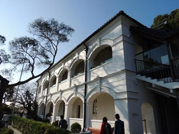
Built in 1902, Tai O Police Station was revitalised into a boutique hotel a few years ago. Many of its original features are well preserved, such as the colonial-style architecture, cannons, corner turrets and cells. From here, proceed to Tai O Bus Terminus for bus connections to other districts. Photo credit: en.wikipedia.org

Click here for a better resolution of Tung Chung to Tai O trail map.
Info:
Area: Lantau Island District
Starting point: Tung Chung Fort
Endpoint: Tai O Heritage Hotel (proceed to Tai O Bus Terminus for departure)
Average hiking time: About 4.5 hours
Distance: About 14.5 km
Replenishing stations: There are no kiosks along the way, so it’s best to stock up at Tung Chung before the hike. Fuel up at restaurants around MTR Tung Chung Station, or sample the amazing array of street food after you finish your hike in Tai O.
Difficulty: Difficult - Relatively long distance with a fair amount of uphill and downhill sections
How to get there:
To the starting point:
From MTR Tung Chung Station Exit B, take bus 3M, 11, 23 or 34 at Tung Chung Bus Terminus and get off at Ha Ling Pei. Follow the signs to Tung Chung Fort.
From the endpoint:Take New Lantao Bus 11 to MTR Tung Chung Station.
A ferry is available from Tai O to Tung Chung and Tuen Mun. From these points, public transport is available to other destinations.
Please click here for the ferry schedule.